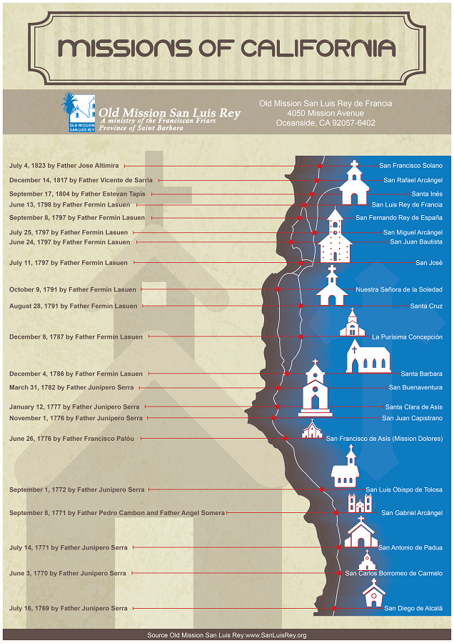
California Missions Map and Route of El Camino Real
The 21 California missions were established along a north–south corridor extending from San Diego to Sonoma. Positioned at intervals along the Pacific coast, the missions formed a connected network that became known as El Camino Real, or “The Royal Road.”
Mission sites were selected based on access to water, agricultural land and proximity to travel routes. Together, they created a continuous chain of settlements across Alta California. The map below illustrates the approximate locations of the missions and the route that linked them.
Geographic Layout of the Mission Chain
The California missions were distributed along a coastal corridor that follows much of present-day Highway 101. The route begins in San Diego in the south and extends north to Sonoma, covering approximately 600 miles.
Most missions were established in valleys or near reliable water sources. Access to freshwater was essential for agriculture, livestock and daily use. Fertile soil and moderate climate conditions influenced site selection, particularly along the central coast where river systems supported farming.
The spacing between missions averaged about 30 miles, a distance that could typically be traveled in a day on horseback. This interval allowed movement of supplies, communication between friars and coordination with nearby presidios and settlements. While terrain varied from coastal plains to inland valleys, the chain maintained relative continuity along the region’s natural travel corridor.
Although the missions formed a connected line, they were not uniformly coastal. Some were located slightly inland to take advantage of agricultural land or defensible positions. Over time, these sites became fixed points within the broader network of Alta California.
What Was El Camino Real?
El Camino Real, translated as “The Royal Road,” was the overland route that connected the California missions, presidios and pueblos. The road developed as travel between settlements increased during the late eighteenth and early nineteenth centuries. It was not originally constructed as a paved highway, but emerged from repeated use along established paths linking mission communities.
The route allowed communication between missions and facilitated the movement of people, supplies and livestock. Military escorts, missionaries and colonial officials traveled along this corridor as part of the administrative system governing Alta California.
In the early twentieth century, portions of the historic route were marked with decorative bells placed along modern roadways. Today, many stretches of U.S. Highway 101 and other major roads follow segments of the historic mission corridor, though the original path varied based on terrain and seasonal conditions.
El Camino Real represents the connective framework of the mission system, linking individual sites into a coordinated geographic network.
Regional Breakdown of the Mission Corridor
Although the missions formed a continuous chain, their locations can be grouped into southern, central and northern regions based on geography and terrain.
Southern California Missions
The southern missions begin with Mission San Diego de Alcalá and extend north through areas that include present-day San Juan Capistrano, San Gabriel, San Fernando and Oceanside. This region features coastal plains and inland valleys that supported early agricultural development. Proximity to the Pacific coastline and established military presidios influenced site selection.
Central Coast Missions
The central portion of the corridor includes missions such as San Luis Obispo, San Miguel, San Antonio, Santa Barbara, La Purísima and Santa Cruz. Many of these were established in fertile valleys between coastal mountain ranges. River systems and arable land supported livestock and grain production, making this region agriculturally significant within the mission system.
Northern California Missions
The northern missions extend through the San Francisco Bay Area to Sonoma. Sites such as Mission San Francisco de Asís, Mission Santa Clara, Mission San Rafael Arcángel and Mission San Francisco Solano mark the upper end of the corridor. Cooler climate conditions and proximity to coastal fog influenced agricultural practices and settlement patterns in this region.
Together, these regional groupings illustrate how the mission network adapted to varied landscapes while maintaining geographic continuity along El Camino Real.
Travel and Distance Between Missions
The average distance between neighboring missions was approximately 30 miles, a span that could typically be covered in a day on horseback. This spacing was intentional and allowed missionaries, soldiers and travelers to move along the corridor with predictable stopping points.
Travel conditions varied depending on terrain and season. Some stretches followed relatively level coastal plains, while others required crossing rivers, hills or mountain passes. During the rainy season, river crossings could become more difficult and portions of the route might shift slightly to accommodate changing conditions.
Movement along El Camino Real connected missions with nearby presidios and pueblos. Supplies, correspondence and personnel traveled along the same corridor, reinforcing the geographic cohesion of the mission system.
The consistent spacing of the missions contributed to the development of a structured network across Alta California, linking settlements across several hundred miles of coastline.
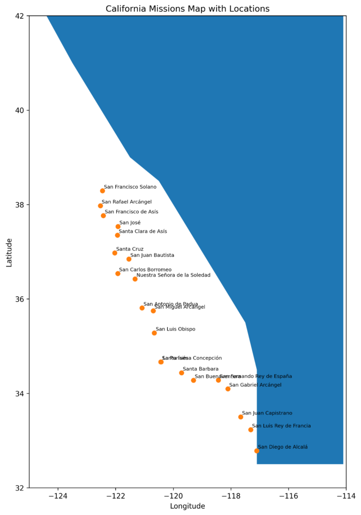
The California Missions Map
The map below illustrates the approximate locations of the 21 California missions along the Pacific coast. Each point represents one mission site, arranged in north–south order from San Diego to Sonoma. The distribution reflects the coastal corridor that became associated with El Camino Real.
While modern highways often follow similar alignments, the original travel routes varied depending on terrain, river crossings and seasonal conditions.
Viewing the missions spatially highlights the continuity of the corridor and the relatively consistent spacing between sites. From the southernmost mission in San Diego County to the northernmost in Sonoma, the chain extends across much of present-day California.
The Mission Route Today
Today, many segments of the historic mission corridor correspond with major transportation routes, including portions of U.S. Highway 101 and Interstate 5. Although modern infrastructure has altered the landscape, the general north–south alignment of the mission chain remains recognizable.
Markers placed along parts of the roadway identify sections of El Camino Real, reflecting early twentieth-century efforts to commemorate the historic route. Some original mission structures remain intact, while others have been reconstructed or preserved as historic landmarks.
As a geographic network, the California missions continue to define a recognizable corridor across the state. The alignment of the 21 mission sites provides a spatial framework for understanding the development of Alta California during the late eighteenth and early nineteenth centuries.